
 Developing Remote Sensing Capabilities for Meter-Scale Sea Ice Properties
Funding Agency: US Office of Naval Research, Arctic and Global Prediction Program
Collaborators: C. Polashenski (ERDC-CRREL), E. Deeb (ERDC-CRREL), and D. Perovich (ERDC-CRREL)
Funding Period: 2013-2018
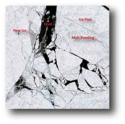
An increasing array of very high resolution commercial satellite assets are opening the opportunity to bridge the gap between low resolution, basin-scale remote sensing data and much more limited extent aerial photography or ground based measurements. These assets provide panchromatic optical, multiband optical, and SAR capabilities at high enough resolution (0.5–2.0m) to directly resolve features like melt ponds, floe boundaries, and individual ridges. Though full basin coverage is not yet realistic at these resolutions, frequent repeat rates at polar sites and substantial data transfer rates from these newer assets mean that meter-scale processes can be monitored at a significant number of sample sites in the basin. Explicitly resolving these meter-scale processes at carefully chosen representative sites could, therefore, provide an important set of data products for modeling and process studies. In addition, these products could provide the validation data needed to further develop and test methods for extracting sub-pixel ice characteristics from lower resolution assets, as has been attempted for melt ponds using spectral mixing techniques. The possibility therefore exists to use newly available remote sensing products to bridge the scale gap between in situ observations of key sea ice processes and basin scale monitoring, permitting a newly comprehensive assessment of meter-scale ice properties that are driving ice evolution. The goal of this work is to develop and validate remote sensing techniques to track key sea ice parameters that occur below the pixel size of most global-coverage satellite assets. In particular, we will develop and field-validate methods for detecting melt pond area fraction, ice surface roughness, and floe size distribution. The work will directly address a particular focus of the Office of Naval Research (ONR) core program solicitation by contributing to “the development of sea ice and ocean products derived from remotely sensed data.”